
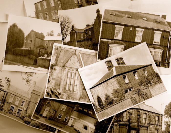
Large Houses
Fell House, Lowrey's Lane, Gateshead
Photographer: Unknown
Date: Unknown
iSee Gateshead Old Pictures Ref: GL003108
Home of Thomas Wilson, The Bard of Low Fell
Really close to my childhood home and my heart. Kells Lane school in background
Advertisement

Beacon Lough House
Photographer: Walton, C.R.
Date: 1964
iSee Gateshead Old Pictures Ref: GL003512
677 Old Durham Road
Date: Date Unknown
iSee Gateshead Old Pictures Ref: GL003350
Item Description: 677 Old Durham Road
White house, High Heworth
Built 1600s Demolished 1960s
Farnacres
Large house of John Barras..click link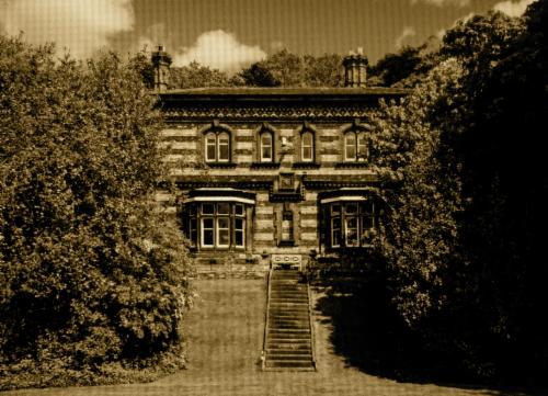
Bracken Dene
More of Bracken Dene's occupants
The Hermitage, home of Clarke of Clarke Chapman fame. For more, go to gatesheadlocalstudies and enter hermitage in search bar
For a Haven sent Holiday Break
Click this Link
Bensham Grove..home of Robert Spence Watson
for lots more
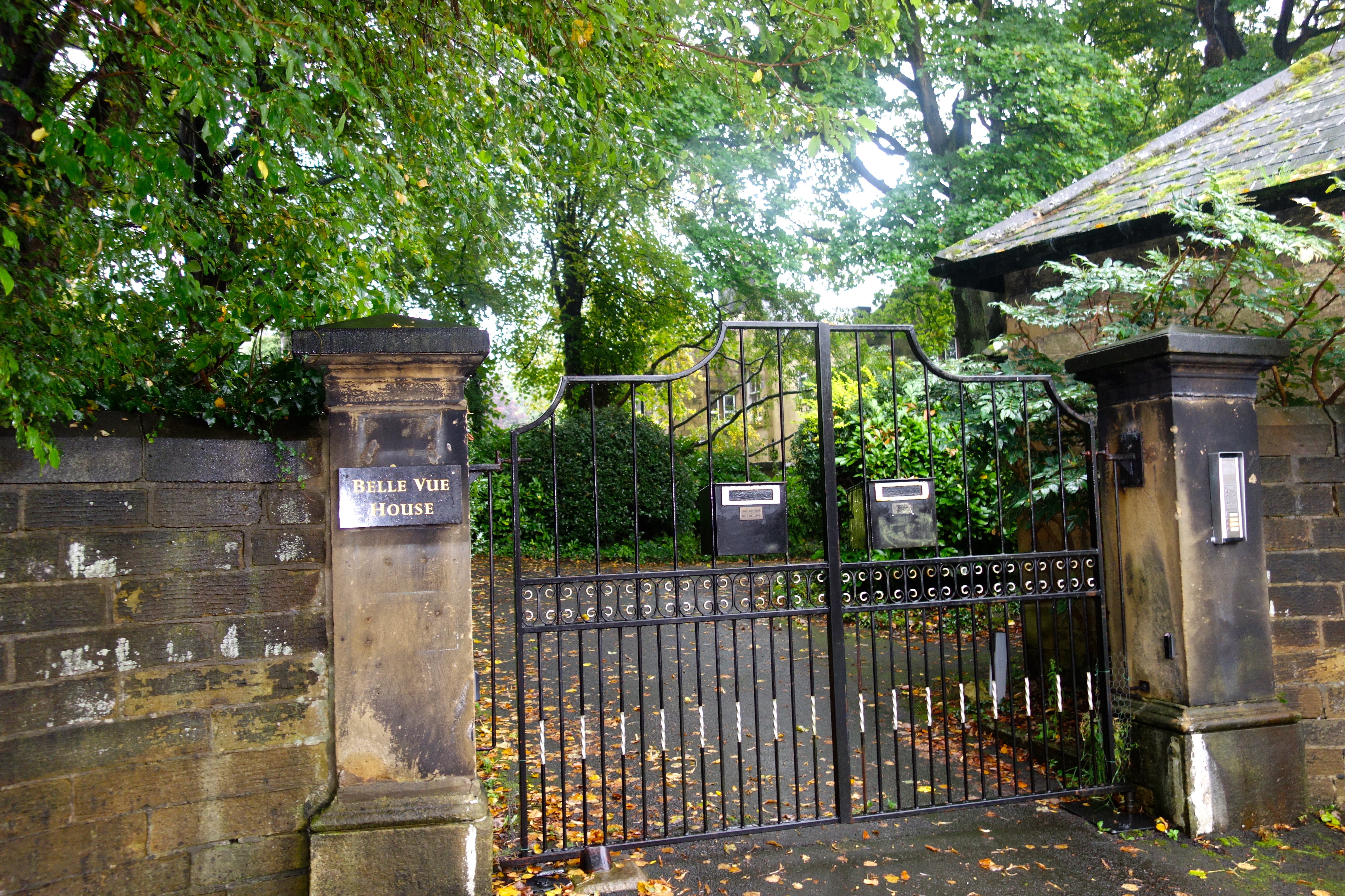
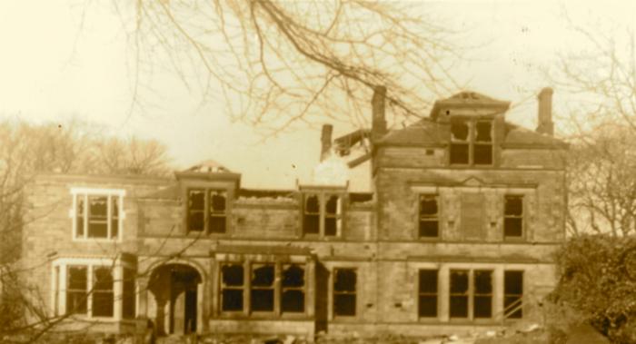
Belle Vue House, home of Abel Henry Chapman
 Some of the notable houses in The Felling
Stella Hall, Blaydon
..see Paul Atkinson's Pillarbox video
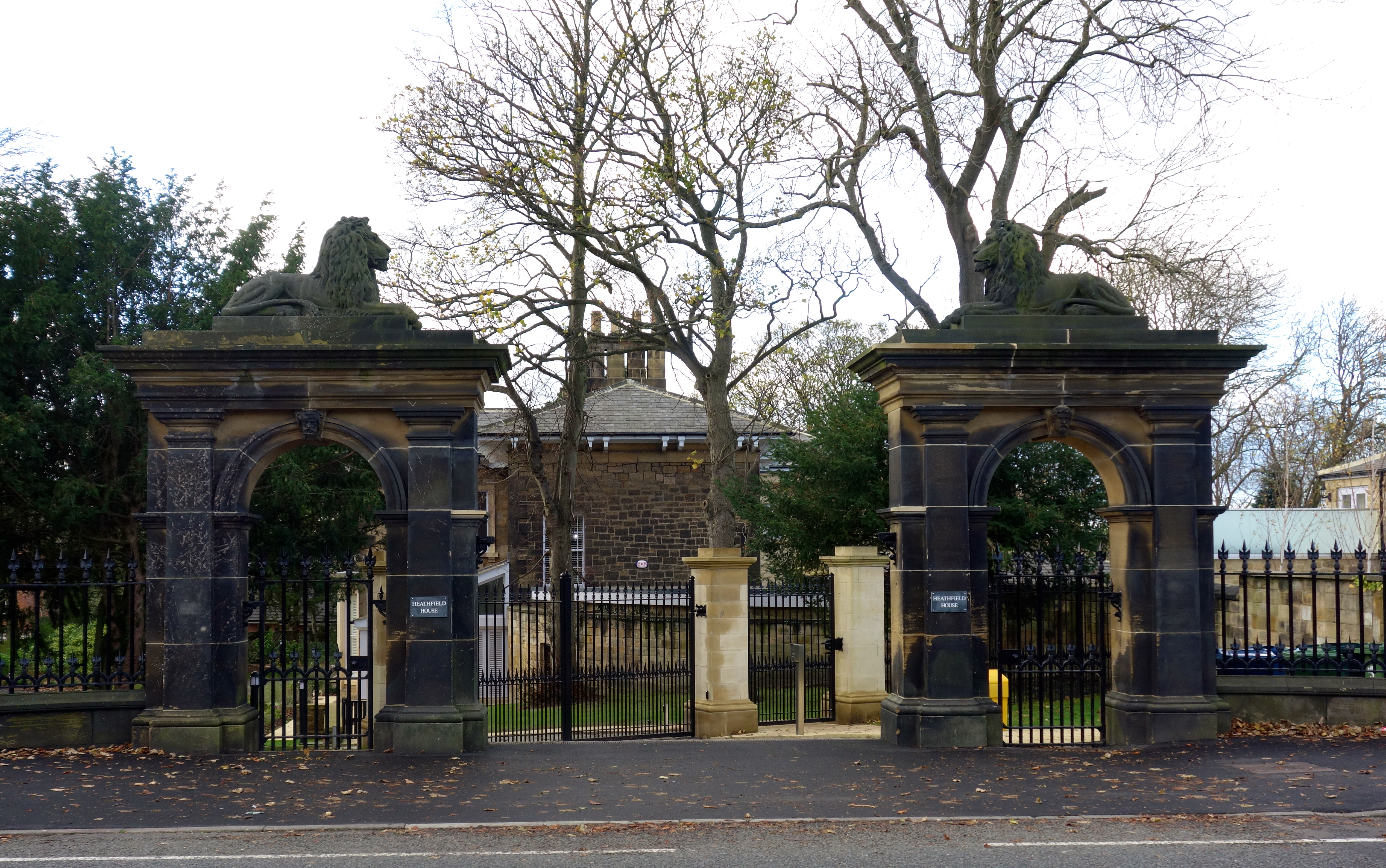
Heathfield, Low Fell
by Hope Dodds
Heathfield was built for Joseph Willis Swinburne,
Gateshead's third town clerk, in 1855. Other occupants include the
Langes and the Lunns.
Heathfield had a conservatory built over the dene and had most remarkable grounds. The carriage gate onto the main road was very elaborate with a tall stone arch on each side and a stone lion on the top of each, like the lions in Trafalgar Square - not quite so big, but a good size. In the grounds there were artificial mountains, complete with winding paths, boulders and pine trees, and a full-size metal eagle on the summit. There were other lions and eagles here and there a lake with a boat and boathouse, and an island in the lake on which stood a glass pagoda. This fantastic place belonged to a family called Lange - I think that was the spelling, but the final "e" was pronounced. My father told me that the two brothers Lange came from Germany and made
their fortune in the coal trade. The elder was a very good business man; he never married. The younger brother married - he was the one with the romantic mind who planned the Heathfield grounds. Whenever he wanted to add a mountain or a few more lions and eagles, he told the other brother, who made some more money and gave it to him to pay for the improvement.
The grounds of all these great houses extended from the main road downhill to a very minor road called officially East Park Road and colloquially the Low Lane. On the east side of the Low Lane were the walls of the great houses, each with a door in it, and one or two with a dreary little lodge, which never seemed to be inhabited. On the west side was the public park, about which there will be more hereafter. It was bounded by tall iron railings so that the grass and flower beds could be seen. There were trees on both sides of the road which was very quiet, with hardly any traffic. The Heathfield grounds extended to the Low Lane, but on the south of Heathfield there was a field extending from the main road down half the side of the Heathfield grounds.
Underhill, Low Fell
by Hope Dodds
Underhill was for many years the home of Joseph Swan who
invented the carbon filament electric light bulb, which was the ancestor
of our present bulbs. He did not belong to Low Fell by birth, as the
Swans were a Sunderland family, but he came to Gateshead about 1845 to
join John Mawson, his brother-in-law, who had a chemist's shop and
chemical works in Newcastle. Joseph Swan lived in Gateshead, working at
problems of lighting and photography. His first wife died in 1862. In
1869 he moved to Underhill and married again, and there his second
family of children was born. The house is now a private school, and the
first electric light switch ever made is still proudly shown there. The
American inventor Thomas Edison was not born until 1847, but in course
of time he began to work on the same problems of lighting. [Underhill
has been renovated and extended and is now sheltered housing for old
people. The electric light switch is no longer there but there is on
display one of Swan's early electric light bulbs.]
He and Joseph Swan
got into touch with one another and jointly launched the Ediswan
electric light bulb. On the 3rd February 1879 in the rooms of the
Literary and Philosophical Society of Newcastle upon Tyne, with Sir
William Armstrong in the chair, Joseph Swan gave a lecture and
demonstration of his new method of lighting. The hall was illuminated by
70 gas jets. When he gave the signal, they were extinguished and 70
electric light bulbs immediately lit up "to the amazement and delight of
those present". He continued to experiment both in the use of
electricity and in the development of photography and received numerous
honours both in England and abroad. When he was knighted in 1904 he had
taken out about 60 patents. He left Low Fell to go to live in London in
1883, and died in 1914.
On this field in the 1920s was built the last of the big houses, not so large as the others, with a garden beautifully laid out and kept. This is called the Chesters, though I do not think any Roman remains were ever found there. [Chesters Park has been built on the grounds of The Chesters which is now a residential care home.] On the lower part of the land there was a house and grounds rather smaller than Heathfield but larger than The Chesters. This was the place I knew intimately, as my grandfather's house. He was the head of chemical works in Newcastle and had a partnership in three chemist shops in the town. The garden at Heathfield was laid out in the romantic gothic style of the early 19th century, but the garden at Ashfield was designed by John Hancock in the still older landscape gardening style and the dene there has always been my ideal of what a dene ought to be. It is true that it had been provided with a quantity of artificial rocks, but they were overgrown with moss and bedded in grass and wild flowers. On the ridge of the steep sides there were four great old Ash Trees which gave the place its name, one at the foot, on the north side, two in the south side and one at the top of the dene, the oldest of all and covered in ivy. The boundary with Heathfield was along the ridge of the north side of the dene, and was marked only by a single strand of wire held up by a few short posts. The good-natured Langes never minded if a child, or even several children, ducked under the wire and wandered about among the wonders of their grounds, but we always liked the Ashfield garden best.
The grounds of all these houses adjoined one another, and there was no road to connect the Durham Road with East Park Road, the Low Lane, before Joicey Road, which was immediately to the south of Ashfield. The side gate of the house opened onto this road and a footpath led through the garden down to the house, but the main gate with its lodge and carriage drive was on the Low Lane, the only main gate on the east side of that road, but there was one house with a gate and drive on the west. side, next to the Park. [Ashfield House is to the rear of Springs Fitness Centre on Joicey Road. The Lodge on East Park Road is of later date (1903) than Ashfield House. The gate on the west side of East Park Road is that of Grove House.]
On the south side of Joicey Lane comes the only estate which was mentioned by Thomas Wilson, Whinney House. When the road was opened in 1826 it must have been a large farm not at all like its later appearance. In the middle-of the 19th century there were four brothers who were colliery owners in Northumberland and Durham, all very rich. The youngest, whose health was poor, was not quite so rich as the others, but he was rich enough to buy Whinney House, build himself a large mansion, and lay out elaborate grounds over the former fields. This was much the largest of these great houses. The grounds stretched from Joicey Road to the first houses in Low Fell village. The principal gate was on the main road with lodge and drive. The grounds extended down past the end of the Low Lane to West Park Road. The dene in the Whinney House grounds was a very large one, to suit the size of the place. There was a deep dip in West Park Road, and at that point there was a third gate into the grounds, not an imposing one in itself, but it had quite a large house for a lodge, with its name on the wall, "The CWM" a puzzle for at least one youthful passer-by, for how could you pronounce CWM? I suppose now that Mr. Joicey thought his valley was larger than a dene, it was a combe. It was very lovely in springtime, full of flowering trees, apple and cherry and red and white hawthorn. [The West Park Road referred to here is now Saltwell Road South. Old maps do not shoe an entrance to Whinney House from West Park Road although there was a house in the dip opposite the Ninepins at the foot of the dene. This house was demolished and two houses erected on the site. An entrance into the grounds of Whinney House is shown on Joicey Road (now an entrance to allotments).]
South from Whinney House, on Belle Vue Bank was the church of St. Helen, dedicated in 1876. There was a sort of tradition that the Joicey family had a good deal to do with the formation of the parish of Low Fell and the building of the church, but probably most of the wealthy people who lived in the big houses were interested in this, as the village of Low Fell was growing. So Low Fell was separated from High Fell and had a church of its own, without the parishioners having to climb up to St. John's church on the top of Sheriff Hill.
[Edward Joicey built St. Helen's Church at a cost of £13,000. ]
This was the Pre-Raphaelite period in arts and crafts, and there are two of William Morris's windows designed by Burne-Jones in St. Helen's church.
[The church has four Morris windows and five by Wailes.]
This brings us to William Wailes, who began life as a grocer in Newcastle, but, having a strongly artistic bent, he began designing stained glass. He had his workshop in Bath Lane, Newcastle, and became very successful supplying windows to churches all over the country. Locally his work may be seen in St. Nicholas, Newcastle, and in St. Mary's, Gateshead. He bought the 60 acres of land between East Park Road and West Park Road, which was the same size as that covered by the houses and grounds of which some account has just been given, from Enfield to Ashfield, but not including Whinney House. At the south end of this estate he built South Dene Towers, a fantastic castellated building in red and white brick, with two towers. This use of red and white bricks, arranged in patterns, was one of William Morris's mistakes. The house was extremely inconvenient, with winding staircases in two towers, alcoves, and galleries. It was at one time leased by Robert Coltman Clephan, who collected medieval armour, and was rather appropriate for his purpose, as there were plenty of odd corners in which knights in armour stood. There was of course a dene in the garden, I think the continuation of Ashfield Dene, but as Mr. Clephan had 10 children, all very lively and active, the grounds were not kept up as they were in the other great houses, and the dene was chiefly used for climbing up the trees.
[South Dene Towers was demolished and the Crematorium and grounds now occupy the site.]
Meanwhile in 1871 Mr. Wailes has built himself another house, larger than South Dene Towers, called Saltwell Towers, in the middle of his large grounds. It was in the same sort of red and white bricks and in the same fantastic pseudo-medieval style. In 1876 he sold the house and 500 acres of land to the Gateshead Corporation, who used the grounds as a public park, and a very fine one. Mr. Wailes continued to live in Saltwell Towers until his death in 1881, and after that it was let from time to time to various tenants. There is a very fine dene in the grounds, the continuation of North Dene. In one place the banks are so steep that there is a high level bridge across, in other parts there are footpaths leading down to a foot bridge across the small stream that flows through it. At the foot of the dene there is a lily pond, and on the boundary a pre-Raphaelite well fed by the stream. Eventually the Corporation acquired the whole of the estate for their public park, and Saltwell Towers became a museum of what are called local bygones, relics of local industries, old prints and pictures of the neighbourhood, records of prominent citizens, a very interesting place .
[The Well is the Salt Well. Saltwell Towers became unsafe and was closed in about 1970. It is now a ruin although the weather vane, complete with Wailes' monogram still stands. Restoration may be carried out as part of lottery-funded park renovation.]
The main gate of Saltwell Park opens on the corner of East Park Road and Enfield Road, which leads up to the main road past Enfield House, the first of the big houses on the West side. Enfield House has just been pulled down and the rest of the estate is covered by a huge new Technical College. [Now Gateshead College]. Bloomfield and North Dene will eventually be absorbed into the college, no doubt. The Red House, to the south of North Dene, was built later than the other big houses. Below it is Ravenshill, once the home of the artistic Sowerbys, the owners of a glass works for which Gateshead was once famous, and where fine glass, much admired in Victorian times, was produced, also the "crackle" glass which fascinated children. [Sowerby's glass is very collectable even today Ravenshill was eventually demolished to be replaced by a modern house built by Sir John Hall of MetroCentre and Newcastle United fame.] The house had a very Pre-Raphaelite hall and an outside frieze in relief with symbols of the four seasons on the West front. For many years now it has been a Social Club. It was reached by a private road and the sites on each side of this were developed a good many years ago by the building of smallish private houses which still stand.
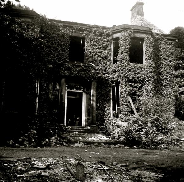
This brings us back to Heathfield. The bulldozer has gone over the grounds, the lake, the pagoda, and the mountain haunts of the eagles. Only the lion gate and the old house remain. A new Grammar School is built on the land which was once such a place of romance. [The school, now comprehensive, has moved to the Joseph Swan School on Saltwell Road South and Heathfield is to be used for housing.] Ashfield next to it is a Civil Defence post and both the house and the garden are sinking into a wilderness, and no doubt will soon be bulldozed and devoted to education instead of fairy tale. [Ashfield became a Teachers' Centre but is now unused. Part of the grounds is taken up by the Springs Fitness Centre; the remainder, as Hope suggests is a wilderness.] South Dene Tower was the A.R.P. centre during the war; and now the fantastic towers are coming down. Whinney House belongs to the Health Department and has been used as a T.B. Sanatorium, a war-time hospital and an old people's home. [Whinney House is now the headquarters of the Gateshead Health Trust, the grounds being largely neglected.] Before the war an open-air school for delicate children was built in part of the grounds, the very pleasant field to the south of Joicey Road, with a grove of cherry trees as a background. [The Open Air School is now closed.]
Having dealt with the houses on the west side of the main road from Shipcote to the village of Low Fell, we must cross to the east side. The two houses farthest to the north were built early in the present century, later than most of the houses on the west. One, Springfield House, still stands behind the later Springfield Hotel. [Springfield House was demolished and the hotel extended.] The other, with a large garden separating it from the main road, is a square red brick building called Lindum House; in the centre of the roof there are two chimney stacks connected by ornamental metal-work, and so the house is usually known as the House with a Handle. It is now the Constitutional Club. South from it there was a succession of fields which were formerly used for corn and hay, then later for pasture, and now they are covered with streets.
Another large house was much farther to the south, about opposite to Heathfield. It was called Musgrave and was built for the Allhusen family, who were of German origin like the Langes, and had chemical works on the Tyne. It is also in the William Morris style, but in a much more agreeable form, with stone walls and a slate roof, no red and white brickwork - rather narrow pointed gables and tall slender chimneys ornamented with plasterwork. The lodge was a low building, with diamond-paned casement windows and a general medievalish look. The garden was surrounded by a high stone wall, above which appeared the tops of rowan trees covered with creamy-white blossom in early summer and with scarlet berries in early autumn. The house and front garden still are there, though I have written about them in the past tense. Musgrave is now a private day school.
South from Musgrave there was another field with a field path on its south side, and this was the first way leading to the upper part of Low Fell since Dryden Road joined the main road almost a mile away. On the south side of this path was rough open ground on which goats and donkeys were sometimes tethered.
Then comes a slightly larger connecting link between the main road and the upper road, Denewell Lane as it was once, now dignified into Denewell Avenue. As my readers have had so much of denes and wells they may be relieved to hear that there is no trace of either in Denewell Avenue. In the 1890s it was a rough farm road going eastward uphill to join Kells Lane and Dryden Lane, with waste land on each side. But near the east end on the south side there were a few detached modern brick houses, in one of which lived Dr. William Henry Davis, the last, as it proved, of a medical family who maintained the health of Low Fell for about a hundred years. The first Dr. Davis lived at Wrekenton at the beginning of the 19th century from about 1810 onwards, when the main road still was along the crest of the Fell and the new Durham Road was unthought of. He was succeeded by his son Dr. Robert Davis, who had two sons, Robert and William Henry. They both became doctors, and removed to Low Fell, though the family home at Wrekenton was still kept up by their sister Miss Jane Springmann Davis, the Grand Old Lady of Wrekenton. When the second Dr. Robert Davis died, the practice was carried on by his brother Dr. William Henry Davis, who did not retire until 1934, and died in 1938, aged 82. So the three generations covered about 130 years. The houses on the south side of Denewell Avenue were built some time before those on the north side,
which was rather strange, as they of course faced north. It might be called the Harley Street of Low Fell, as at one time there were four doctors and a dentist living there.
The houses on the north side of Denewell Avenue, with a south aspect were not built until after the war of 1914-18, in the 1920s, and the corner site on the main road was the last to be built. This is usual enough, as the corner site is the most expensive, but on the opposite side of the road Denewell House was one of the earliest to be built in about 1900.
To the south of it on the main road, there was a small house with a small but very well-kept garden, and then a terrace of small houses, in one of which there was what may be called a dame's school - two sisters had about a dozen little boys and girls under school age as pupils in the morning only.
Denewell House still stands, but all the rest of this stretch of buildings is now a range of modern shops.
Now we come to the most important crossing in Low Fell, where Beaconsfield Road (once Buck Lane) comes down hill from east to west, crosses the main road, and becomes Belle Vue Bank. At the north west corner where Belle Vue Bank begins there was once an inn called the Spade and Rake, in order to appeal to gardeners; there were market gardens on the Fell, as Thomas Wilson tells us, and there were the gardens and grounds of the big houses already described - the name must have been meant to appeal to them. But as the New Cannon Inn was just across the main road in the south east corner of the crossing, the Cross Keys Inn, now the Belle Vue Hotel was only a short distance along the main road to the south, and the Beehive Inn was a short distance down Belle Vue Bank, it is not surprising that the Spade and Rake could not survive so much competition.
The inn was turned into a private house, the yard in front of it into a walled garden, with a little fountain in it, there was a gardeners' cottage next the house, and the outbuildings were cleared away and became the site of the Midland Bank. The house was called Fountain House, from the little fountain in the garden which could be turned on by a tap. It was an inconvenient name as there is a Fountain Terrace in Gateshead, and another Fountain House in Bensham. From the 1890s onwards the house was occupied by an elderly American gentleman, Mr. Cutter, and his English wife. Mr. Cutter continued into the twentieth century to wear the costume of Sherlock Holmes, deerstalker cap and ulster with a cape. In warm weather he wore a cloth cap, not a deerstalker, but he never wore a hat or went bareheaded. After his death his widow lived on in the old house, cared for chiefly by her gardener, who lived in Fountain Cottage. The house was very old-fashioned, with stone floors, cold and comfortless, but when she died she left a large fortune to a deserving charity. I do not think she was a miser; it just never occurred to her to alter her way of living.
The people who took the house after her death, and renovated it, found from the old deeds that it had once been the Spade and Rake Inn, so they changed its name to Spade-Rake.
South of the cross roads the main road is very wide for a short distance, according to Macadam's original design of a road for coaches, a road for horses and a footpath. On the west side this design is still preserved to some extent - there is the main road, a wide footpath, and on the other side of the footpath a narrow cobbled road, now a parking-place for motors. On the east side the footpath is wide, but there is no trace of the horse road. [The area referred to is that in front of Wilson Terrace (Lloyds Bank, Post Office, etc.). It is now all pavement.]
At this point I must apologise to my readers for having misled them by conjecturing that Boggins Dyke Neuk was on the west side of the road. An old plan of Low Fell shows that Boggins Dyke was on the east side. Of course it is just possible that the Dyke was on the east and the Neuk was on the west. Behind the houses on the east side of the road the ground rises so steeply that in one place there are steps going down from the upper north and south street to the level of the main road. These steps go down into what was once a farmyard, from which there is a short entry into the main road. This very wide part of the road was once called the Garth. Perhaps it was the large yard containing the outbuildings of a farm which continued to exist long after the Garth had become part of the great North Road. Down to the 1930s the farmer used to keep a herd of cows, which solemnly processed across the road twice a day and went to their field down Belle Vue Bank, but the motor traffic became too much for them, they were no more and their field was built over. [I have been unable to trace the farmyard referred to or the steps. But I would suggest the area is around about the rear of the Kwik Save Supermarket.]
We have now reached the part of Low Fell which has already been described in the account of the making of the new road. The Institute and Library associated with Thomas Wilson is on the west side of the road in the section where the three traffic lines may still be traced. Here on the wide footpath there are trees which grow remarkably well considering the difficulties of their position. There is also a memorial to the soldiers who died in the Boer War of 1898 to 1902. South from this the road is lined by shops and inns for some distance; then there was formerly a large stone house with a garden given up chiefly to trees and surrounded by a high stone wall. These premises were all removed about 1950, and except for the destruction of the trees it was not much loss. There is now a line of small shops and offices where the house formerly stood, and the garden has been turned into a wide expanse of concrete pavement. The whole is the Low Fell Shopping Precinct. [The shopping precinct referred to is by the footbridge. The house demolished was Saltwell Vale.]
On the east side of the road opposite to the new precinct is a row of small stone houses on the summit of a steep rise with long gardens reaching down towards the road, and divided from it by a built-up drop of about five feet, so that the passer-by is on a level with the flower beds at the foot of the garden but well above the footpath. In very bad weather one or another of the walls may collapse onto the footpath owing to the pressure of wet earth upon it. This terrace must have been built in the 1870s. Continuing south on the east side of the road one passes the Wesleyan Chapel and Southern Memorial Hall, the Gateshead Arms public house and the foot of Engine Lane. Here another terrace begins, red brick houses built early in this century, well above the road and with gardens sloping down to it. But after a few of these comparatively modern houses come much older ones. The terrace is called Victoria Terrace and must have been built quite early in Queen Victoria's reign, probably in the 1850s. The brown stone houses with their little gardens in front are on a level with the street.
At the end of the terrace there is a large stone house, the Gables, which was built by Mr. Steele the colliery manager, who also built Home House in the 1820s. It is scheduled as a building of architectural interest. A short time ago an application was made to the corporation to allow it to be converted into a garage. The applicant said he would use the house as offices and preserve its outward appearance, while the garage would cover the large garden; but the municipal authorities replied that as there was a garage only a few yards to the south of The Gables, and another about 20 yards to the north, they did not consider that another was required at that point.
Just before the old borough boundary there is a disused bus station, and the place is still called the Terminus because the old steam trams and after them the electric trams used to end their course there. [The terminus building is now the shop of a locksmith at the foot of Kells Lane.] Here Kells Lane joins the main road and continues down Chowdean (P.O. spelling) Bank to Lamesley a very awkward crossing as it is diagonal from north east to south west.
Turning north round the corner into Kells Lane, we come to the present bus station, which is the terminus for one line of buses. Here on the east side of the road is the Victoria Inn; though it has been somewhat renovated it is an old building, probably it was given the name of Victoria in 1837, when the young queen Victoria came to the throne. Branching off from Kells Lane up hill to the east there used to be a rough cart track with an untidy little stream flowing beside it, this unmade road was called ironically Pimlico. After climbing up two fields it came to a place where there was a high steep hill on the north, and a lower but also very steep hill on the south. Here a couple of planks were laid across the stream to form a bridge and a path crossed it, going north and south. On the south side the path went up the hill almost overgrown by thorn trees and elders, and on the top of the rise was a small, whitewashed cottage with a red tiled roof, and a garden going steeply down to the stream. The path went on south growing into a cart track through the fields to Greenwell Farm, and beyond the farm to the Ravensworth Golf Course. At the south end of the golf course there was a clump of trees, and beside it another small whitewashed cottage with a red tiled roof. Here the path crossed a road (Peggy's Bank) and continued as a cart track until it reached a third whitewashed cottage with a red tiled roof. A family of children in the neighbourhood used to call these the cottages of the three witches, because in fairy tales when the princess loses her prince she goes to the cottages of three witches in succession, who each give her a gift by which she finds him. Returning now to the first witch's cottage and the plank bridge over the stream, on the north side half a dozen irregular stone steps led up to the Plantation, a hillside so steep that it has never been built over, and in the 1890s was covered with trees. [All the area is now built up and there remains no evidence of the buildings referred to.]
In the 1920s a number of detached houses were built along the top of the ridge with gardens sloping down to the rough private road on the west. Their front doors, garages and smaller gardens were on the level land to the east at the top of the rise. The private road comes out into Church Road just opposite to a large stone house called Woodlands, built in 1870. At the entrance to the Plantation a path climbs the hill; it used to have wooden steps at the steepest part, but the gradient and the surface have since been improved. On the very top of the hill was a ventilating shaft for one of the old pits, properly surrounded by a high and strong stone wall. On the north edge of the Plantation, beyond this path, there was a little well, a stone trough into which the water bubbled up, or poppled, in the local dialect, so it was called the Popplewell, and the nearest house in the Plantation is called Popplewell House.
Now all this has vanished. Pimlico is a broad highway called Southend Road going up the hill through a new housing estate, and the farms, the fields and the cottages are gone. The little streams are put underground in culverts, and occasionally have the satisfaction after heavy rain of flooding the high roads. The Plantation is on the eastern edge of Low Fell, or perhaps a little beyond it, and I may have trespassed on High Fell. The Ravensworth Golf Course, however, remains; - it is nowhere near Ravensworth, which is on the other side of the Team Valley; it lies just below Wrekenton.
A month after I wrote the last paragraph the Popple Well showed what it can still do in 1966. The situation is this. Church Road-goes up hill due east till it reaches the private road into the Plantation on the south and the large house called Woodlands on the north. There Church Road turns north and continues up hill. On the east side there used to be a rough bank with few trees on it, and somewhere in that bank was the Popple Well. In the 1920s (I think) one small house was built there, but for a long time it was not popular, and often stood empty. The tenants complained that the garden slipped down into the road now and then, and they were afraid that the house would slip after it. However in the 1950s the demand for houses was so great that this side of the road was built over, and the houses seem to keep in place all right. The Popple Well disappeared.
On the west side of the road the hillside was still steeper, but houses were built there as early as the beginning of this century, as one may know from the name of one of them, Spion Kop, a memory of the Boer war.
These houses are built right under the steep hillside. Their top storeys are on a level with the road, and from it steps lead down into the back yards. During the first fortnight of February 1966 there was almost incessant rain or snow. In the third week, the bad weather still continuing, the west side of the road with the wall and the steps down to the houses, collapsed into the backyards. Nobody was hurt, but it is a terrifying experience to have a hillside with a wall in it falling into one's backyard. I don't know the exact position of the Popple Well in relation to the landslide, but I can't help thinking that the underground spring had something to do with the collapse. All the rain and melted snow may have piled up a head of water underground which finally burst out of the steep hillside. The fragments of the landslide were cleared out of the back yards and deposited in the road, which was effectively blocked, with only a footpath left. The effect was strange, as the houses and gardens above the road were undamaged, so the road was blocked with rubble which had no visible origin, as the back yards from which it came could not be seen.
Below the place where the landslide occurred are some of the oldest houses now standing in Low Fell. Lord Ravensworth held property here before the enclosure of the common in 1806-16. In 1803 he sold the property now called Rosehill and on it was built a house of the usual Georgian type, four large square rooms on the ground floor and four similar rooms above. The demand for houses was great then as now, and two more houses were built onto the first, each with two rooms on the ground floor and two above, and in addition attics. These two houses stood in the fields and had large gardens. They are now reached by a private road with a gate and have become so completely surrounded by other buildings that even near neighbours do not know of them.
Kells Lane, on the west of Rosehill branches off from the old Durham Road at the Three Tuns Inn and comes down hill south west. On the east side there are several detached houses standing in their own gardens. One of these named
Kells Lane passes the large detached houses and some terraces, going downhill in a south-westerly direction. At the foot of the slope it makes a slight turn and goes directly south. At this point Beaconsfield Road crosses Kells Lane and goes directly east up a steep hill and at the same point Dryden Road branches off due north past the top of Denewell Avenue.
In 1907 the Newcastle upon Tyne Presbytery bought the site at the corner of Denewell Avenue and Dryden Road. This was a judicious move as the fields between Denewell Avenue and the large house called Musgrave were then being built over. To the north of Denewell Avenue Heathfield Road replaced the old field path. Still going north Joicey Road, which once ended at the main road, was carried on uphill eastwards to Dryden Road, and north of that again Musgrave Road was made by the side of the big house. Dryden Road was extended as far as Musgrave; beyond that it was still a cart track. A terrace of houses was built along the made road, and on the main road on the west there was a row of semi-detached houses. Between these two roads, Dryden Road and the main road, now A1, Low Fell garden city was built, that is, the terraces called Beech, Holly, Fern, Hawthorn and so on, instead of having separate little gardens, had a large garden area between every two terraces, the garden space being divided up by fences to give each house its own piece, and with footpaths only between the houses and the gardens - all traffic was along the back streets. This has proved a boon to the householders since the traffic on the main road increased so much with the development of the motor car.
With all this new growth of population round it the Presbyterian Church at the top of Denewell Avenue prospered and the congregation increased. In seven years time they were able to replace the corrugated iron church with a large stone church, using the old one as a church hall. The new church was opened by the service on Good Friday, 10th April 1914.
Southward along Kells Lane is the large stone house built by Mr. Kell, the first town clerk of Gateshead after the place became a municipal borough in 1835. The area which was once a large garden behind the house has for many years been a field, but within the last two or three years a Roman Catholic church has been built there, and the old house is its presbytery. [The Roman Catholic presbytery and St. Peter's R.C. Church.]
When the new main road was constructed the inhabitants of Low Fell walked to Gateshead or Newcastle if business took them there, unless they had horses and carts, or donkey carts, or pony traps or rose to a carriage and pair. But the railway was approaching, though slowly. Although it was possible to go from York to Gateshead by railway in 1844, and the great cast-iron High Level Bridge was built across the Tyne and opened in 1849 the Team Valley line was not built until some years later, and Low Fell Station was not opened until 1857. It was right down in the valley reached by the road down Belle Vue Bank, which was never properly made in its lower part. Several large houses with pleasant gardens were built down by the station by business men who found the trains convenient, but though there are made roads and terraces of houses round about the site now, it was not much used, and not much missed when it was recently closed during the severe reduction of railway traffic.
About the same time as the opening of the railway station a much more popular form of transport appeared on the main road, an omnibus from Low Fell to Newcastle. This in its turn was superseded by steam trams.
These were the usual means of transport in the 1890s. They ran on a single line from the old south boundary at the top of Chowdean Bank to the Gateshead end of the High Level Bridge. They were remarkable looking objects. The engine was square, and covered with metal sheeting. It had a tall chimney to carry off the smoke from the furnace. The driver had a look-out window in the front. I think there was a fireman to look after the furnace and the boiler, as well as the driver, as on a railway engine. The passenger coach was in two storeys, and so twice as high as the engine. The top storey, covered by a roof, was for smokers. The seats were on each side and the passengers faced one another. There was of course a conductor. These trams ran on single lines, with a loop line at intervals where those going in opposite directions could pass. In 1900 steam trams were superseded by electric trams, with a double track, and all the usual mess and misery of relaying the road. At first they were very apt to break down, and the conductors' stock excuse was that "the juice was off", the juice being the electric current. But they had the great advantage that they went over the High Level Bridge to Newcastle. In course of time they were supplemented by motor buses, and now they have gone altogether and all public transport is by bus.
Notes..to be developed
Now divided into flats. The house is situated on Durham Road Low Fell, the entrance being 'guarded' by a pair of large stone lions.
Enfield House
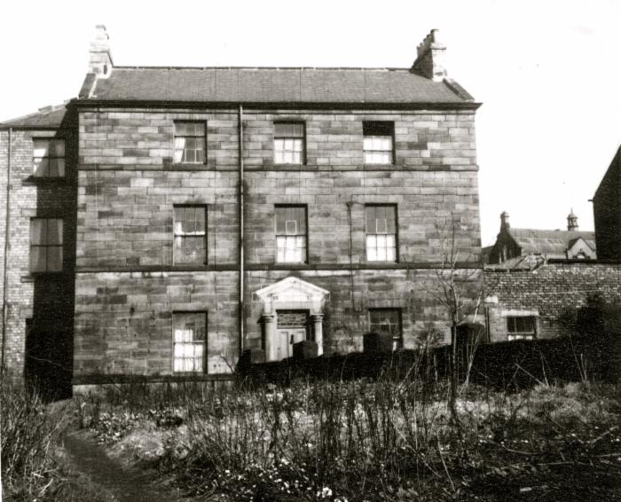
North Dene
House with the handle
North Dene
North Dene, the building and the grounds were still very nice in the early sixties when it was used as overspill accomodation for The Grammar School for Boys It has was absorbed into Gateshead College and the grounds turned over to portacabins and tarmac for car parking. As of 2014, the property is being redeveloped into flats.
Two-storey, neo-Classical villa of ashlar sandstone and a Welsh slate roof shown on the First Edition OS plan, 1862. One of a cluster of large houses built on the west side of Durham Road. When constructed it was situated within a formal landscaped garden (HER16307). By 1897 a lodge had been added to the Durham Road entrance. The gardens were within dense woodland with a curved carriageway. Despite the construction of the college close to the house in the mid 20th century the grounds survived into the 1960s with the lodge still appearing on the 1974 OS plan. The house was converted into North Dene Technical College in the 1950s. At this time fireplaces were blocked up, new windows inserted and a first floor toilet extension added. The house retained an array of decorative plasterwork and ceilings and other period features. A billiard room extension was added in 1887. The house was recorded in 2008 by Addyman Archaeology and later in 2012 by URS. Demolished ahead of residential re-development of the site.
Whinney House
The Chesters
Large Houses photos, some courtesy of Gateshead Council, brought to you by
The Felling Heritage Group